A Smarter Way to Explore Greece
The official Visit Greece website and…

Mapping Ancient Athens
© https://mappingancientathens.org/en/home/
Renowned for its iconic landmarks and richly-layered history, the city of Athens is jam-packed with archaeology. Home to the famous monuments of the Acropolis and the medieval Daphni Monastery, both UNESCO World Heritage Sites, Athens has been continuously inhabited for over 5000 years, making it one of the world’s oldest cities.
While the Classical, Roman, and Byzantine heritage of the Greek capital is represented just about everywhere you look, less well known is the “invisible” urban fabric buried below the modern surface, including evidence of the adaptive use of spaces, buildings, and civic infrastructure by ordinary Athenians over the millennia.
These missing pieces, whilst hidden from view, have been surveyed and recorded over the course of 160 years of systematic archaeological excavations in the city. The remains of ancient houses, roads, cemeteries, cisterns, production sites (e.g. pottery workshops) are all sitting below the surface; an archaeological palimpsest of cultural and urban development from the Neolithic to the modern day.
A recently launched digital topography project by the Dipylon Society, “Mapping Ancient Athens,” has, for the first time, gathered together data from all of these excavations, covering an area of 6.7 square kilometers in the historic center. With financial support from the Packard Humanities Institute, the Stavros Niarchos Foundation and the Aegeas Non-Profit Civil Company, the 4-year project (2018-2021) has retrieved data from 1,473 excavated sites and developed an open access digital map.
The area covered by the project corresponds to the part of the ancient city that was enclosed by the Themistoclean Wall (479 BC) and the Valerian Wall (c. 260 BC), as well as a 500-meter wide outer zone encompassing the two ancient fortifications.
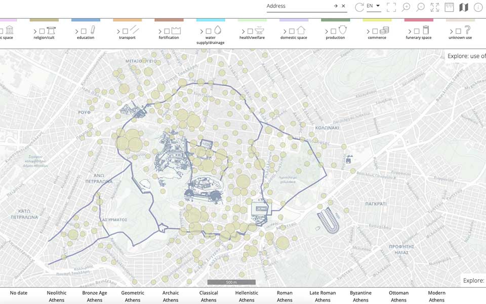
The open access map allows users to browse 160 years of archaeological excavations in the city.
© Mapping Ancient Athens
Categorised into 11 historical periods, from the Late Neolithic (c. 3000 BC) to the modern era, the project team gathered together data from all the archaeological rescue excavations that have taken place in Athens over the last 160 years, compiling detailed information from site reports published in academic journals and conference proceedings.
Rescue excavations are mandatory under Greek law, carried out by members of the Greek Archaeological Service prior to any construction work, from large-scale public works to smaller interventions on private plots. Their primary objective is to safeguard and record all existing archaeological remains below the modern surface. Extensive works have been carried out in Athens over the past 160 years, including underground pipes and cables, building plots, the widening of roads, parking facilities, and, more recently, the construction of the Athens Metro and tram network.
Over the course of the study, the research team geo-referenced 670 published rescue excavation plans and linked them to descriptions using 1,400 bibliographical references. Processing such a vast amount of data required the input of 240 archaeologists, working in close collaboration with the Ephorate of Athens in the City of Athens.
It is the first digital map of rescue excavations in Athens, and the most comprehensive topographic study of the city ever undertaken.
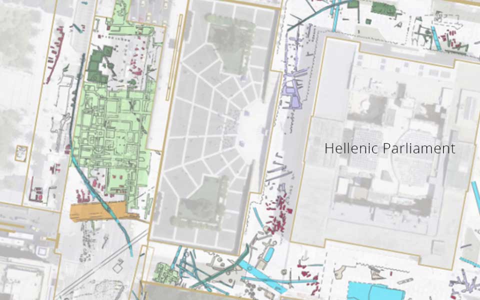
Archaeological remains are shown in relation to the modern urban fabric.
© Mapping Ancient Athens
Launched in October, the Mapping Ancient Athens project uses Geospatial Enabling Technologies (GET) to pinpoint the precise location of archaeological remains below the modern surface, lists their typological classification (e.g. kiln, cistern, courtyard), and provides a detailed chronology based on the published reports.
Available in Greek and English, the digital map allows users to browse excavation sites around the 6.7 square kilometer area of the city, applying criteria for basic or more advanced searches.
It is hoped that the map will provide a useful research tool for archaeologists, heritage management professionals and urban planners for future technical projects, as well as a fun and interactive resource for interested members of the public to learn more about the urban development of Athens and the history of archaeological excavations in the city.

The map will facilitate the ongoing work of the Greek Archaeological Service.
© Mapping Ancient Athens
Founded in 2014, the Dipylon Society is a non-profit organization for the study of ancient topography and the cultural environment through interdisciplinary research on archaeology, history, informatics and cartography.
The Dipylon Society collects, organizes and disseminates information about archaeological sites using cutting edge technology, specifically GIS and web-mapping. Through its various projects, including Walk the Wall Athens and Athens Western Hills, Dipylon works in close collaboration with the Greek Archaeological Service and members of the academic community to raise awareness among the general public about existing archaeological resources in Athens.
For more information, visit the site: mappingancientathens.org
The official Visit Greece website and…

The permanent removal of scaffolding from…

New restoration works are revealing how…

Newly discovered artifacts at the Kolona…