Weekend Escape: Kalambaka and the Monasteries of Meteora
A perfect weekend getaway: wander among...


A view along the Argolis Trail, near the Karathona area.
With the Peloponnese Trails project, the Region of the Peloponnese aims to establish the area as one of Greece’s premier hiking destinations. The network comprises 11 long-distance routes covering a total of 1,729 kilometers and has been developed through the project “Upgrade and Enhancement of Existing Hiking Trails in the Peloponnese Region – Peloponnese Trails,” implemented in collaboration with Parnon Development S.A.
Stretching from Corinth and Mount Parnon to Argolis, Messinia, and Monemvasia, the trails connect areas of outstanding natural beauty with historic sites, myths, traditional villages, and cultural landmarks. Most of the network has now been restored, opening up these historic routes to walkers once again.
“The dirt paths have been cleared, debris and dense vegetation removed, minor restoration work carried out, and new waymarking installed to ensure the routes are safe and accessible. We’re not creating new trails – we’re reviving the old footpaths our grandparents used every day,” says Dimitris Laloudakis, a member of the project’s social cooperative, as we hike along the Mount Parnon trail after leaving the village of Melana behind.
As the path winds through olive groves and dry-stone walls, the view gradually opens onto the Argolic Gulf and the Myrtoan Sea. Before long, we reach the small chapel of Church of Aghios Georgios, one of the trail’s designated stopping points. From its hillside vantage point, the panorama stretches all the way to the islands of Hydra and Spetses.

“When we began searching for the routes, we turned to our parents, the village elders, and local shepherds to show us the old footpaths and share the stories behind them,” say the people involved in the Parnon Trail project.
The vision for a single hiking network spanning the entire Peloponnese was inspired by the success of the Menalon Trail, Greece’s first certified long-distance hiking route. According to Dimitris Laloudakis, the original idea came from Giannis Lagos, whose name has become closely associated with the development of the Menalon Trail.
“The idea is to set out from one village, hike for four or five hours – depending on the length of the trail and your fitness level – and arrive at another village where you spend the night. The following day, you continue from there. It’s essentially one continuous trail,” explains Giorgos Alexandrou.

“We’re not creating new trails; we’re following the old footpaths our grandparents used every day,” the trail guides tell us as we hike through Mount Parnon.
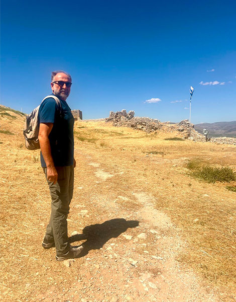
Dimitris Kintis guides us around the Larisa Castle of Argos, where the trail passes just outside the fortress, offering sweeping views across the entire Argolic Plain. Προτιμώ αυτή την απάντηση
Today’s trail network builds on routes first mapped out about six years ago. They have since been expanded with new sections and adapted to meet the requirements of the relevant European certification standards. Yet, those involved in the project say the trails’ distinctive character comes from their faithful alignment with the historic footpaths that have connected communities for generations.
“In just 45 minutes, you can leave the coast behind and find yourself in the mountains. Along the way, the scenery changes constantly. You experience an extraordinary variety of landscapes within a single hike,” says Alexandrou. Laloudakis points to another advantage that sets the Peloponnese apart from many other hiking destinations in Europe. “These trails can be enjoyed for almost ten months of the year. Depending on the season, you can choose either a coastal or a mountain route and enjoy hiking in ideal conditions.”
In addition to showcasing the Peloponnese’s natural beauty and cultural heritage, the project also aims to breathe new life into small villages whose populations have steadily declined in recent decades.
“If just a few groups of hikers pass through a village each week, they’ll stop for a coffee, have lunch at a local taverna, buy regional products, or spend the night at a guesthouse. For the local community and economy, that can make a real difference,” Laloudakis says.

Depending on the season, visitors can choose either a mountain or a coastal route and experience the diverse landscapes surrounding Mount Parnon.
Laloudakis recalls a recent hike during which local residents became an integral part of the visitors’ experience. “Three elderly women prepared traditional pies and showed participants how to knead bread. These are the kinds of experiences visitors truly appreciate because they offer a genuine glimpse into everyday village life.”
For Giorgos Alexandrou, the value of the trails extends far beyond walking and connecting with nature. “The trail passes through villages, traditional settlements, and places of remarkable architecture and history. Along the way, there are local tavernas, guesthouses, and people who are eager to share the stories of their homeland. It’s not just about the route – it’s about the entire experience.”
Both Alexandrou and Laloudakis believe that international recognition for the network could help create new incentives for people to remain in – or even return to – rural communities. “As visitor numbers grow, people may decide to renovate an old house, open a guesthouse, or develop a tourism-related business,” Alexandrou says.

The most scenic section of the Argolis Trail. “That’s also why it’s the most demanding,” remarks Dimitris Kintis.
© Dimitris Kintis

Near the Karathona area and the Church of Aghios Nikolaos Krasoktistos, one of the landmarks along the route. The letter “A” is used to mark the Argolis trail network.
Connecting hiking with history, culture and the unique identity of each place lies at the heart of the Peloponnese Trails project. That vision became even more evident a few hours later, when we visited the Argolis Trail.
Stretching for approximately 97 kilometers, the route follows the curve of the Argolic Gulf, linking Xiropigado with Epidaurus through a landscape rich in natural beauty, archaeological sites, and historic pathways. We meet Dimitris Kintis, a historian and manager of the social cooperative responsible for designing, restoring, and waymarking the Argolis Trail, at Larisa Castle, the ancient acropolis of Argos. The trail passes directly below the fortress, where sweeping views open out across the Argolis plain. For Kintis, the trails are more than a way to discover a place; they also offer a different way of experiencing time.

Map of the 11 Peloponnese Trails.
“They are an exercise in slowness,” he says. “A rejection of speed, instant gratification, and the relentless pace of modern life. Trails teach us to experience time differently.” As he explains, the Argolis Trail was designed to reveal the region’s remarkable historical continuity. Unlike other parts of the Peloponnese, where mountainous terrain dominates, hikers here encounter coastal landscapes, fertile plains, Mycenaean roads, and monuments spanning thousands of years of history.
“In Argolis, the trails are carriers of memory,” Kintis says. “As you walk, you can find yourself on Mycenaean roads dating back to around 1500 BC, passing through places connected with mythology, antiquity, the Byzantine era, and modern Greek history.” From Larisa Castle, the trail continues toward Tiryns, Nafplio, and Asini, crossing a landscape where the traces of successive civilizations exist side by side. Along the way, hikers encounter the remarkable Mycenaean Bridges of Argolis, engineering monuments that have stood for more than 3,000 years.
For Kintis, there could be no more fitting destination than Epidaurus. “Epidaurus embodies everything this trail seeks to convey. Most people know it for its ancient theater, but the area has a much deeper history. It was one of the ancient world’s most important healing centers, a place where people traveled from afar in search of healing, knowledge, and spiritual renewal. Arriving there on foot, following a route that weaves together the landscapes and history of Argolis, gives the experience an entirely different meaning.”
As he points out, the aim of the Argolis Trail is not simply to guide visitors to famous monuments, but to reveal the landscape that connects them. “The architect Dimitris Pikionis used to say that we come to know a place through the effort of our own bodies – we know it by walking. I believe that anyone who walks through Argolis will come to understand the true spirit of the region.”
With information in Greek from kathimerini.gr
Hermes Trail – 176 km
Stretching from the shores of the Corinthian Gulf to the landscapes of Mount Ziria, the Hermes Trail links coastlines, forests, and traditional villages. Its symbol is the winged sandal of Hermes, the patron of travelers.
Heracles Trail – 203 km
Inspired by the labors of Heracles, this route connects Argolis, Corinthia, and Arcadia. It passes through Nemea, Lake Stymphalia, and the Katavothres of Feneos, combining mythology with spectacular natural scenery.
Korinthia Trail – 67 km
Following the historic route from the Corinth Canal to Mycenae, this trail links ancient ports, medieval castles, and some of Greece’s most important archaeological sites.
Argolis Trail – 96.8 km
Running from Xiropigado to Epidaurus, the trail follows the Argolic Gulf through Argos, Nafplio, Tolo, and the Mycenaean Bridges of Arkadiko. It’s an ideal route for travelers looking to combine hiking with history and mythology.
Menalon Trail – 75 km
Crossing the heart of mountainous Arcadia, the Menalon Trail connects historic villages, monasteries, and the Lousios Gorge. It was Greece’s first trail to receive the European Leading Quality Trails – Best of Europe certification.
Pan Trail – 62 km
Named after the god Pan, this trail follows rivers, gorges, and stone bridges through Arcadia, showcasing the region’s rugged landscapes and mythological heritage.
Arcadia Trail – 161 km
This mountain trail connects historic settlements, archaeological sites, and landscapes deeply associated with the Arcadian ideal. Highlights include the village of Vasta and the remarkable Church of Aghia Theodora.
Parnon Trail – 220 km
The longest circular route in the network showcases the landscapes of Mount Parnon and Tsakonia, linking Paralio Astros, Tyros, Melana, Leonidio, Kosmas, Kastanitsa, and Ano Doliana. It combines sea and mountain landscapes, traditional villages, monasteries, and one of Greece’s most distinctive cultural traditions.
Messinia Trail – 260+ km
The longest trail in the network stretches from Ancient Messene to Voidokilia Beach and Mount Taygetus, showcasing archaeological sites, castles, lagoons, and dramatic mountain scenery.
Sparta Trail – 112 km
Linking Mystras and Sparta with the villages of Mount Parnon, this route highlights Byzantine heritage, ancient history, and the landscapes of Laconia.
Monemvasia–Maleas Trail – 96 km
From the medieval fortress town of Monemvasia to the Cape Maleas Lighthouse, this trail follows one of the Peloponnese’s most spectacular routes, where mountains, sea, castles, and wild landscapes come together.
The project is being implemented under the National Recovery and Resilience Plan Greece 2.0, with funding from the European Union through NextGenerationEU.
A perfect weekend getaway: wander among...

Mild weather and a slower pace...

With world-class routes and a growing...
We spent a quiet weekend in...