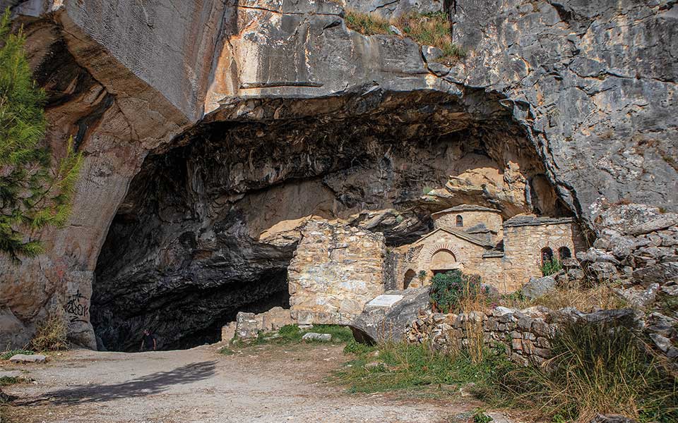
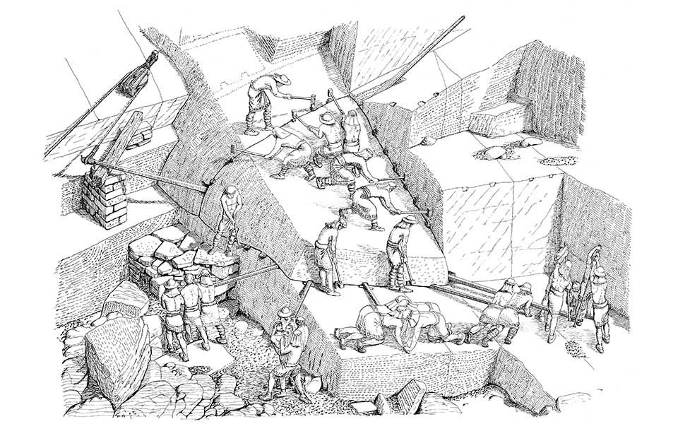
In the sunshine, the marble stones are dazzlingly bright. The harsh sounds of tools intermingle with human voices as the stonemasons discuss the day’s work or make casual conversation. Pieces of marble that have been separated with care from the mountain’s embrace rest on the Attican soil, while craftsmen prepare for their long, painful, and hazardous journey to the Acropolis.
The enormous marble stones are guided with care to the beginning of the road along which they will be transported down the mountain via a method of controlled rolling. Then they will reach the “lithagogias” (or “stone-bearing”) road, where they will be loaded onto carts destined for the construction site of the Parthenon. The excavations and studies of archaeologists have brought enough evidence to light to enable us to imagine scenes from the day-to-day work at Davelis Cave (aka “Amomon Cave”) on Mount Pendeli in the mid-5th century BC.
© Stephie Grape
Today, two-and-a-half millennia later, stonemasons have abandoned Mt Pendeli’s ancient quarry for good. In the area around the cave – which remains a popular spot for weekend excursions – one encounters cyclists, carefree hikers, motocross bikers, families laden with picnicking gear, and, of course, rock climbers; the climbing routes of Davelis Cave are among the oldest and more well-known in Attica. A couple is enjoying the November sunshine on the plateau in front of Davelis Cave this early Sunday morning.
Inside the cave, a small group of friends take in the space, while one of them recounts myths, legends, and stories. These include how the brigand Christos Davelis once had his hideout here (a fact that has never been confirmed); the works that were carried out during the military dictatorship (1967-1974) and late 1970s by the Ministry of National Defense; how, in antiquity, there was a temple here dedicated to the god Pan; and how during the Byzantine era it was a monks’ hermitage (the source of the name “Amomon Cave”). There is even a conspiracy theory that connects it to satanic rituals.
The cave is impressive, with an almost mystical atmosphere. Gazing at the walls and the jagged ceiling full of stalactites, one feels a certain sense of wonder. The first to discover it were the ancient craftsmen who extracted the marble that would be used as material for the construction of the Parthenon. They created the entrance to the cave, and it is said that a portion of the cave itself was created by the excavations of the stonemasons over the years.
© Stephie Grape
© Stephie Grape
The marble road
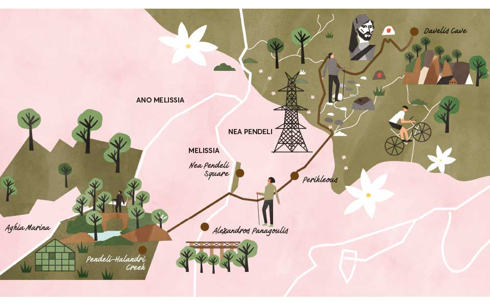
While the cave itself is well known to the residents of both the immediate and the broader area, there’s much less public awareness of the old marble road which begins just a few meters away and is as close as one can get to a journey back in time to the Golden Age of Athens and the creation of its greatest monument. In total, over 20,000 tons of Pentelic marble were used in the construction of the Parthenon. The beginning of the road of “katagogi” (“descent”) is marked by a fallen marble column. The way is littered with slippery pieces of Pentelic marble, small and large, which reflect the light of the sun as it climbs higher in the sky. It is rather stunning to realize that nearly 2,500 years ago, on this same path, one could hear the marble being rolled down to the waiting carts, while the surrounding steep mountainsides echoed with the cries of the workers who’d taken on the mammoth task of transporting it to the building site. It’s estimated the journey took about six hours in total.
The ancient road has long been known to historians and archaeologists. The route was described by Manolis Korres, professor of historical architecture at the National Technical University of Athens and head of the Acropolis Restoration Service, in his book “From Pendeli to the Parthenon” (Melissa Publishing House, 1994): “The transport route began from the bottom of the road of the ‘katagogi’; it followed the right bank of the creek of Halandri over a distance of about four kilometers, then the left bank for a distance of another four, after which it approached the route of Kifisias Avenue, overlapping with a section of it, and then through what today is the National Garden and the southern slope of the Acropolis. It ended immediately past the Sanctuary of the Nymphe at an elevation of 96m where it intersected with another road, which (running along the western side of the Odeon of Herodes Atticus) led to the Acropolis.” More recent excavations and finds support his descriptions.
A well-kept secret
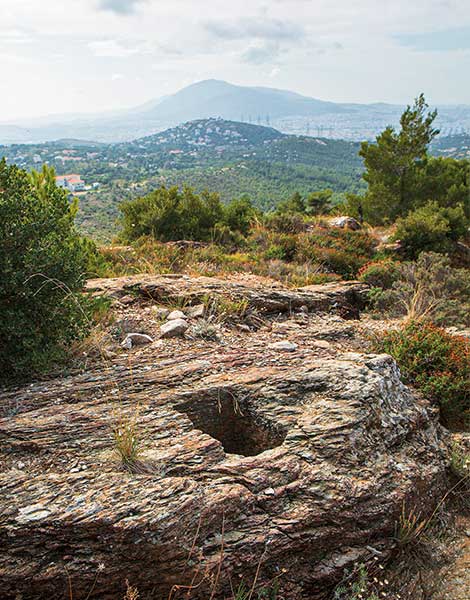
If you decide to walk down from the cave on the old marble road, note that the way forks after about 250m. You should follow the left, narrower, and more downhill path, taking care as it is quite steep. It is easy to see that this is the continuation of the route, as it is strewn with pieces of marble, while the right branch is a dirt road. Make sure to take in the views as you walk, but watch your step, too. From this elevation you can see all of Athens laid out before you, with the sea in the distance and the slopes of Mt Pendeli around you. After about half a kilometer – estimate roughly 700m from the start of the ancient road – there’s a well-hidden secret. A few meters past a pine tree growing in the middle of the path, the path curves to the left. Right at this bend, look for a small pine tree on the left and you’ll see the well-hidden entrance to a very narrow path that’s partly overgrown, with large stones scattered around. Proceed carefully, and look for some large square holes on the rocks to your left. Wooden supports, to which ropes were fastened to regulate the marble stones’ descent, were placed in these holes. The holes are about 30cm wide and 35-40cm deep.
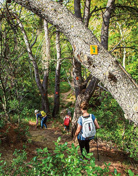
Returning to the path, a descent of about another half kilometer takes you to a dirt road that will lead you to Perikleous Street. Makeshift signs in red, yellow, and blue paint that indicate you are on the correct path can be seen at various places on the big rocks in the center and near the trail’s edge. The vegetation is limited to small trees and bushes which offer no shade – if you take your walk on a warm, sunny day, make sure to have a hat with you – but soften the look of the landscape. Here and there, persistent wildflowers and aromatic herbs grow, spreading familiar scents.
Walking the entire length of Perikleous Street, you’ll pass Tristrato – the point where three paths meet – where you can hear the hum of the electricity pylons there, a sound that resembles the babble of a brook or the rustling of leaves. You’re now moving through a residential area, heading for the confluence of Perikleous and Iroon Polytechniou streets near the square of Nea Pendeli. Turn left here, follow Alexandrou Panagouli Street and cross the stone bridge with care, as the sidewalk is quite narrow. About ten meters after the crossing you’ll see the entrance to a path on your right. This path, about two kilometers in length, has been signposted by the nature lovers’ group Vrilissos and will lead you to the area of Aghia Marina in the district of Melissia in about 45 minutes.
© Illustration: Philippos Avramides
An idyllic refuge
The contrast between the rocky terrain of the mountain and the lush vegetation alongside the creek is fascinating. The path is shady, flanked by tall trees and lined with bushes and seasonal flowers. At different points, the creek itself is visible: a rivulet of water flowing gently along the base of a gully. If you follow this route in the winter or spring, the flow of water is greater and its sound cool and soothing, an idyllic refuge just a few meters away from the noise of the city. There are both uphill and downhill stretches, with some of the latter being particularly treacherous due to fallen leaves and pine needles. Despite the fact that ropes have been fixed at one or two locations for you to grab and progress securely, having walking sticks and, of course, the right shoes – hiking boots are preferable – will help. Sturdy footwear will be particularly useful at the points where the path meets the stream and you need to step in the creekbed to continue your walk.
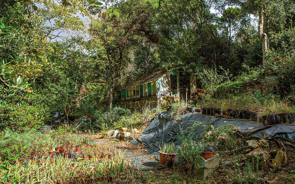
Along the route you’ll encounter a charming plant nursery, near the stone bridge of Asklipiou Street. A few minutes further on from there, you’ll reach Aghia Marina and the end of this section of the creek. From there, take Palaion Latomeion Street to reach the impressive five-arched, marble Doukissis Plakentias bridge (Greek for “Duchess of Plaisance”). This all-white bridge was built in 1836 out of Pentelic marble; its construction was funded by the Duchess of Plaisance, Sophie de Marbois-Lebrun. This is the oldest surviving bridge in Athens and was also used for the transport of marble in the first half of the 19th century – this time for the construction of Athens’ royal palaces when, by order of King Otto, the Pendeli Quarry was re-opened.
A short distance from the bridge is Thyras Park, where you can relax and rest from your walk, thankful that you’re not a 5th-century BC worker hauling marble all the way to the Acropolis, a further 14km away.


