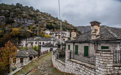
The Metsovo Way: A Model for Mountain Resilience
How Metsovo thrives against the odds...

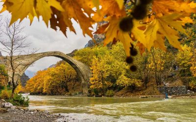
Enormous beech trees encircle Arkoudorema, a tributary of the Aoos River.
© Nicholas Mastoras
One of the most classic and beloved hiking routes in Greece begins from the Aoos Springs Lake, traverses Valia Kalda and ends in Vovousa. It is long, but has many downhills and level sections. There are constant changes in landscape and the natural environment is of such beauty that your fatigue will simply “melt away.”
The toughest incline is at the beginning. It takes approximately three hours to reach the banks of the Aoos Springs Lake on the Flega Peak (2,159 meters). The path begins in forestland, and continues as a dirt road. Pass the Mavrovouni refuge and enter the alpine zone, which takes you to the summit. On a clear day, you can see the lake below and the surrounding peaks. A bit further along you come to the two Flega lakes, home to alpine tritons, while the way down to Valia Kalda is dotted with robola pines that have been struck by lightning. From this point you navigate through thick vegetation, in the heart of the Valia Kalda National Park.
The sunlight does not penetrate the foliage, there is an abundance of streams and the sound of running water fills the air. The tall beech trees, the ground carpeted with fallen leaves and a brisk chill accompany you for the next two to three hours, until you meet Arkoudorema, a tributary of the Aoos River. Walk parallel to the water along a serene route until Smixomata, where Arkoudorema meets the Aoos. Following the course of the river will take you to the Vovousa refuge.

On the side of Grevena, Valia Kalda is a paradise for mushroom lovers, while herds of cows and flocks of sheep and goats can be found on the outskirts.
© Nicholas Mastoras

© Nicholas Mastoras
Make your first stop on the Flega Peak to admire the view and regain your strength. Have a snack on the banks of the big Flega Lake, filled with water from the springs, which feeds the second lake further down as it overflows. If the sun is too strong, it may be preferable to stop in the Valia Kalda forest for a cooler, more refreshing break. There is also a drinking tap, a two-hour hike into the forest. Turn left towards Vovousa as soon as you come across Arkoudorema, and a few meters down you will find a plateau by the water, an ideal resting place. Sit on the cut tree trunks for a picnic and some rest. You can make a final stop where the tributary meets the Aoos River.
The Flega lakes were formed from the tears of the dragon Ligos, who cried when he heard that his friend Pindus was killed by his brothers. “Valia Kalda” means “warm valley” in the local Vlach dialect; they say this area got its name because it is surrounded by tall, exposed peaks and the valley was a refuge during bad weather. The brown bear is known to live in the outskirts of the valley, hence the name Arkoudorema (“bear creek” in English).

The two lakes under Flega Peak. Soon you will leave the alpine landscape behind and enter the thick vegetation of Valia Kalda.
© Nicholas Mastoras

The toughest section of the route is the uphill to Flega Peak, at an elevation of 2,159 meters. The stunning landscape, featuring the high peaks and slopes of the Pindus, is well worth the effort.
© Nicholas Mastoras
This long hiking route requires exceptional physical condition, mainly stamina. The steep incline to the Flega Peak and the section along Arkoudorema will test your strengths. Yet this route features unique natural beauty, with constant changes in landscape that make it worth the effort. Keep in mind that it will take several hours and you need to be well-equipped with walking batons, clothes and food, so you can hike at your own pace, making as many stops as you need along the way.
There are no sections of the route that require particular climbing or mountaineering skills, although you should be careful during the last part as you walk next to Arkoudorema and the Aoos River, since you will sometimes have to walk over the water.
The route can be shortened if you have an off-road vehicle. You can drive to the Mavrovouni refuge and a little further to bypass a significant part of the steep inclines. You may also complete the hike in the reverse, starting from the Vovousa refuge and heading to the Aoos Springs Lake or the Flega Peak.
Either way, it will not be easy to carve a cyclical path in this region, so be sure to have arranged your transport to the starting point or your return to your vehicle.
The total distance from Aoos Lake to the Vovousa refuge is 24 kilometers. From an altitude of 1,400 meters by the lake you will reach 1,840 meters at Mavrovouni refuge and 2,159 meters on Flega Peak. This is the highest point of the hike, followed by a descent to around 1,000 meters in altitude, at the Vovousa refuge. Depending on your pace and the stops, the route can take you 8-12 hours.
How Metsovo thrives against the odds...
Discover five mountain destinations where crisp...
The goddess Artemis, the Virgin Mary,...

A steep and curvy drive high...